Lesson Two: Wyoming – A Land of Many Resources
Grade Level: 3rd Grade
Time: 45 minutes
Essential Question: How can we be stewards of Wyoming’s mineral and energy resources to benefit current and future generations?
Objectives: Students will study and compare maps of Wyoming and Florida to better understand the unique energy resources available to our state.
Purpose: Students learn about the importance and variety of energy resources in Wyoming.
Required Materials/Resources:
-
- One set of the Energy Resources images printed to larger scale, 1 picture per 8.5 x 11 page
- https://www.eia.gov/state U.S. Energy Information Administration website (Sources 1,2)
- “What Do I Notice?” note sheet (one per student)
Suggested Teacher Preparation:
-
- Practice setting and resetting the layers on the energy maps of Wyoming and Florida on the https://www.eia.gov/statewebsite. (If it is not accessible, screenshots are available to use on a document camera or projector.)
Standards:
Social Studies: SS5.5.2 (Practiced/Encountered)
ELA: 3.RI.5, 3.RI.7, 3.RI.9, 3.SL.1.c,d (Practiced/Encountered)
Vocabulary:
-
- Coal – a black/dark brown rock made from old plant matter found mainly underground. Coal is mined and used as fuel.
- Hydropower – electricity produced from machines that are run by moving water
- Natural resources – sources of life, materials, or energy that we are able to get naturally from the earth
- Oil – a natural liquid formed from plants and animals that lived millions of years ago that can be refined into gasoline, diesel fuel, jet fuel, wax, asphalt, and many other valuable products
Instructional Procedure/Steps:
-
-
- Hold up each Energy Resource image. Have students chorally respond what energy resource it is and if it is an example of a renewable or nonrenewable resource. Use this as an opportunity to clear up misunderstandings from Lesson 1.
-
-
-
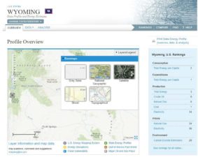
- Open two tabs with the link https://www.eia.gov/state. On one tab, choose Wyoming. On the other, choose Florida. Click on the “Basemaps” option, and select either the Gray Base or National Geographic choice for your maps. (See screenshot below.)

- Open two tabs with the link https://www.eia.gov/state. On one tab, choose Wyoming. On the other, choose Florida. Click on the “Basemaps” option, and select either the Gray Base or National Geographic choice for your maps. (See screenshot below.)
-
-
-
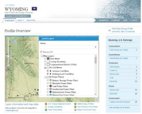
- Click on the “Layers/Legend” option, and “Remove All.” Then select a layer for each map. (see screenshots below) The first one should be “All Coal Mines” and “Fossil Resources” further down the list, click the + sign next to “Coal Field.” The triangles are coal mines; the gray shaded areas are coal fields.

- Click on the “Layers/Legend” option, and “Remove All.” Then select a layer for each map. (see screenshots below) The first one should be “All Coal Mines” and “Fossil Resources” further down the list, click the + sign next to “Coal Field.” The triangles are coal mines; the gray shaded areas are coal fields.
-
-
-
- Pass out the “What Do I Notice?” note sheets. With the “All Coal Mines” and “Fossil Resources,” select “Coal Field” layer, show the Wyoming map then the Florida map. Give students time to jot down what they notice. When all students are finished, in the “Layers/Legend” option, click “Remove All”. Students should see that Wyoming has the resources, and Florida does not.
Teacher Note:
If you have access to individual/small group computers, a possible extension activity is to have students choose other states to compare to Wyoming.
- Pass out the “What Do I Notice?” note sheets. With the “All Coal Mines” and “Fossil Resources,” select “Coal Field” layer, show the Wyoming map then the Florida map. Give students time to jot down what they notice. When all students are finished, in the “Layers/Legend” option, click “Remove All”. Students should see that Wyoming has the resources, and Florida does not.
-
-
-
- Repeat the process with the following layers:
-
-
-
- “Oil and Gas Wells and Platforms” and “Fossil Resources” – click the + sign “Tight Oil/Shale Gas Play” and “Sedimentary Basin.” Gas wells are blue; oil wells are dark brown; gas/oil fields are the shaded tan areas.
- Click the + sign next to “All Power Plants” select “Hydroelectric Power Plant.” The hydro plants are raindrop icons.
- Click the + sign next to “All Power Plants” select “Solar Power Plant” and “Wind Power Plant.” The solar plants are sun icons. The wind plants are turbine icons.
- Click the + sign next to “Coal Power Plant.” Coal power plants are black circle with white triangle icons.
-
- After comparing the maps with all of the layers, discuss the following prompts with the whole class:
-
-
-
-
- “What did you notice between the maps of Wyoming and Florida?”
- “What is special about Wyoming?”
- “What does this say about the importance of energy resources in Wyoming?”
Analysis
In this task, students will be engaged in the higher order thinking skill of analysis.
-
-
-
Students should be able to identify that the state of Wyoming has vast energy resources and a variety of resources that are able to be accessed. That is how Wyoming is unique.
Assessment:
Have students complete the summary on the bottom of the “What Do I Notice?” note sheets. Collect, and check that students mention the vast amount and variety of energy resources in Wyoming.
Credits/Sources:
-
-
- U.S. Energy Information Administration – EIA. (n.d.). Wyoming: Profile Overview. Retrieved June 27, 2017, from https://www.eia.gov/state/?sid=WY
- U.S. Energy Information Administration – EIA. (n.d.). Florida: Profile Overview. Retrieved June 27, 2017, from https://www.eia.gov/state/?sid=FL
-